Flood-models from community-mapped drainage data
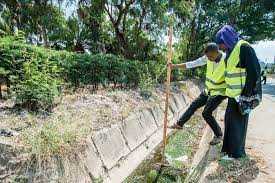
Flood risk maps in the Global South are often non-existent, limited in coverage, innacurate, or out of date. The Ramani Huria community mapping project in Dar es Salaam was a joint venture between Open Street Maps' Resliience Academy and Delft University of Technology to develop a flood model using community mapped drainage data. Over a three year period, university students used smartphones to survey the location and characteristics of "culverts, ditches, drains and decommissioned drains" and whether they were open or closed, and the kinds of materials might be blocking them (e.g. vegatation, rubble, etc). After developing a hydrodynamic model and calibrating it with observed flooding, the researchers determined "that drainage data collected with a community mapping approach allows for reliable simulations and a detailed understanding of flood patterns on street level."
This points towards a future where similar efforts will make it "possible to run reliable flood model simulations that can inform urban planning, investments, and upgrading in flood-prone areas, also in environments where extensive drainage data is usually missing."


..png)
